G Rankine, J Baker, G Turner, Beckett Rankine, UK
Presented at the 35th PIANC World Congress 2024, Cape Town, South Africa. Download the paper (PDF).
View all papers from the conference (via PIANC.app.box.com).
Abstract
Across the world in recent years, many complications have impacted on port development resulting from several world events that have been beyond the control of developers. The port of Freetown in Sierra Leone is expanding to accommodate more and larger vessels, especially for the handling of bulk cargoes. This paper focuses on the creation of the new ship berth at the Nectar Sierra Leone Bulk Terminal (NSBT), to demonstrate how substantial modern port construction projects can be achieved in West Africa, in the face of multiple complications, utilising creative and sustainable solutions. The project was to plan, design and construct the new ship berth adjacent to the existing berths whilst providing good navigational access. With limited spare land available inside the terminal, any newly reclaimed land would also help with port storage and operations. This paper provides explanations and technical details to expand on how the port design and dredging campaign was adapted to the specific requirements of the project, focusing on port planning, structural, geotechnical, and contractual issues.
Introduction
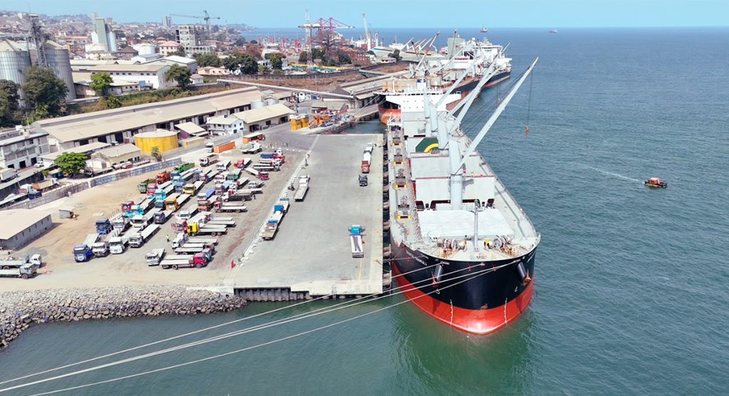
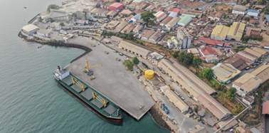
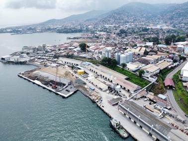
Freetown, Sierra Leone, is home to the West African Coast’s largest natural harbour. The historic port is a bustling hub of import/export and a significant source of the country’s economic prosperity. It is divided into two concessions by the Government of Sierra Leone, one of which is owned by UK’s Nectar Group, operating the NSBT bulk and break-bulk terminal since 2015 following a successful international tender, see Figure 1 below.
Substantial improvements have been made to this terminal in that time, including new handling equipment and improved warehouses, security and lighting to improve user experience. One recent green initiative has been the installation of a new roof-mounted 120 kWP PV solar system and 80kWh battery positioned on NSBT warehousing and office buildings. This is to provide reliable, continuous availability of power to support the terminal’s increasing activities. In the wider community, NSBT has been at the forefront of supporting the campaign to improve the quality of life for young girls and women in Sierra Leone.
NSBT’s concession agreement required a terminal expansion to introduce a new third berth. This substantial project initiated in 2020, has now been implemented to meet the requirements of the Sierra Leone Ports Authority (SLPA), greatly increased port capability and support larger vessels 225m long. Flexibility, efficiency and creative problem-solving have been integral to the delivery process from the beginning for a project that has at times been complex and challenging. Beckett Rankine has been NSBT’s consultant for design and project management services, with Eiffage Génie Civil Marine (EGCM) appointed as construction contractor for the works.
Following initial designs, the owners initiated early contractor involvement in the shape of an NEC4 contract, which takes a relatively new approach to connect the Client, Contractor, Project Manager and Supervisor. The contract aids a collaborative approach, with a framework for rapid design adjustments to optimally respond to the unique challenges of the site.
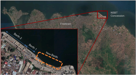
The New Berth
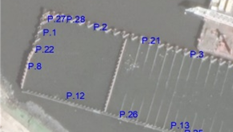
The only available place for construction of the new berth was at the eastern end of the existing berths. Here, the shape of the terminal and its coastline prevented continuation of the same berthing line and called for the new berth to be set at an angle, the degree of which was defined following consideration of water depths, ground conditions and anticipated current flows, see Figure 2. With previously constructed berths formed of various
piled and masonry structures, several options were considered for the structural form, including steel sheet piles and concrete blockwork, while the berth placement was initially selected as the best alignment based on the seabed contours.
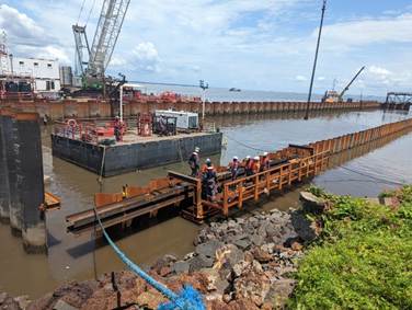
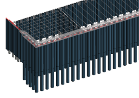
As early-stage site investigations were hindered by the COVID-19 pandemic and a limited budget and timeframe, the designers opted for a flexible approach. Using a range of ground models based on contemporary and historic information available for the site, the structure was therefore designed as a reasonably conventional, standard steel combi-wall. This was made up with large tubular piles and interconnected sheet piles in the form of a cofferdam with a continuous sheet piled anchor wall, see Figure 3.
From the start of the procurement process, there was additional pressure on the project timeline to start critical activities before Sierra Leone’s rainy season between May and November. When the price of steel rapidly elevated along with significant delivery delays – a likely side effect of the pandemic delaying production and disruption from the Ukraine war – the design had to change to recalibrate, adjusting the steel tube sizes to suit availability while achieving the same result within the same time frame. Then later, further reanalysis and adjustment was required when observations from the site during piling for the new berth showed that some of the ground was softer than had originally been anticipated.
This challenge required a considered approach of a rapidly mobilised Cone Penetration Test (CPT) campaign and some strengthening of the steel structure, combined with a carefully orchestrated plan for sequencing the reclamation within specified zones to minimise stresses and movements within the structure and the ground. To avoid a delay of several months in procuring new steel that would need to be shipped from overseas, a portion of steel that was already on site was redistributed without compromising its integrity. The structure was then re-analysed with updated geotechnical parameters. In addition to minimising delays, this solution reduced the overall energy consumption of the project by avoiding the energy use and transportation emissions that procuring new steel would have needed.
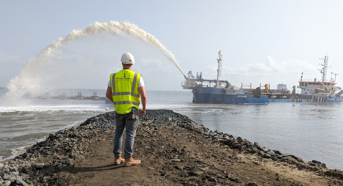
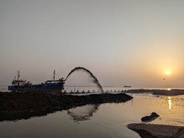
Learning from previous projects in the area and available information of the geology around the harbour, good quality hydraulic fill material was sourced from a nearby area of seabed. This avoided the need to source material from onshore quarries, which would have provided good fill but at a much higher cost and greater disruption to the local roads due to increased vehicle movements. A reasonably small dredger (with a hopper capacity of approximately 1,000m3) was used because it allowed careful placing of fill in the structure at a controlled rate, using both rainbowing and piped delivery techniques, see Figure 4.
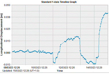
In view of the softer and variable ground conditions, monitoring the structure during construction was particularly important to ensure safety and integrity of the berth at all construction stages. Multiple prisms, tiltmeters and settlement markers were placed on the new steel walls and within the reclamation for a sophisticated, automated monitoring system that gave real-time results as to how the walls moved throughout the process. As a result, the dredging and reclamation was undertaken adopting an observational approach to minimise the impact on the structures; the movement of the walls was tracked against predicted values to ensure their stability.
Construction Contract
The project was executed utilising the NEC4: Engineering and Construction Contract Option C. This is a target cost main works contract with an activity schedule. The reason for using this contract was because it is compatible with the complex nature of the project and it shares the overall project financial risk between the client and contractor. In turn, it aims to induce collaboration throughout the project process as it incentivises the parties to work together to minimise spend whilst not compromising on quality.
The X22 Early Contractor Involvement clause, a relatively recent addition to the NEC suite of contracts, was also used. This clause means that the Client and Contractor enter into a single contract to develop and agree the scope and prices in Stage One before advancing into the construction phase, Stage Two. Early Contractor Involvement is increasingly recognised as a beneficial procurement strategy for complex high value infrastructure projects. It provides the opportunity for the Client and Contractor to work together so that the needs of the project are fully understood and so that the full capabilities and knowledge of the Contractor can be utilised to optimise the design for the preferred methods of construction.
Stage One – Early Contractor Involvement
The Stage One Early Contractor Involvement for the Freetown Port Expansion Project was executed successfully under a tight timeframe and utilising the local knowledge gained by the Contractor whilst working on a neighbouring project. In Stage One, the parties:
- Offset the structure from its previous position and realigned it. This optimised the volume of dredging needed and minimised the interaction of the new structure with existing Berth 1.
- For little extra cost, increased the berth’s hinterland area through additional reclamation. This provided the Client with additional area within their concession for storage and other port operations.
- Changed elements of the structural form i.e. used revetment structures built out from the shore instead of steel retaining walls to minimise the cost.
- Removed an offshore mooring dolphin and walkway from the design, replacing it with onshore mooring points for ease of construction and to reduce cost.
- Streamlined the design such that it was compatible with the proposed construction methodology, ensuring it corresponded to the contractor’s available plant/equipment and their preferred ways of working.
- Identified long lead times for items requiring procurement and shipping, for example, the tubular piles, the sheet piles and the fenders. In fact, the structural steel order was placed before moving from Stage One to Stage Two as this was identified as an item that could delay the start of the construction stage if not delivered to site in a timely manner.
- Identified the skills required to undertake the project which allowed the mobilisation of the correct people at the right time.
Stage Two – Construction Phase
The Contractor mobilised to site in early 2022 bringing with them their site team, a construction barge, a storage barge, a Multicat, a crew vessel, a 200t crawler crane (for use on the construction barge), an 80t crawler crane (for use landside) and the appropriate piling hammers. The site office was erected immediately behind the shore in a convenient location where the new berth was to be constructed. All steel (including tubular piles, sheet piles and tie rods) was shipped and transferred at the port to the storage barge. The Contractor also fabricated two pile guides, for the installation of the tubular piles and sheet piles respectively. Where possible, local staff and suppliers were used in the construction of the new berth.
All designs completed by Beckett Rankine had been modelled using Autodesk Revit Software, a BIM package for accurate and well-defined construction drawings, allowing precise and quick material take-offs and clash detection, see Figure 5.
Further designs of non-critical path items and items without long lead times were completed in Stage Two, again considering the Contractor’s preferred methods of working and with the aim of minimising the cost of the works. These items included:
- Berth drainage;
- Onshore drainage diversions;
- Shoreline protection revetments;
- Berth pavement; and the
- Electrical distribution network.
Ground Conditions
Sierra Leone is a resource-rich country and therefore most geological research and campaigns have focussed on the mineralogy of the inland geological structures. In contrast, knowledge about the geology and geotechnical behaviour around the coastal areas, is extremely limited. This lack of publicly available data on the geology, alongside limited records of historic development, with specific reference to the coastal plains of the Freetown Peninsula, has added to the complexities of understanding the ground conditions at the project site.
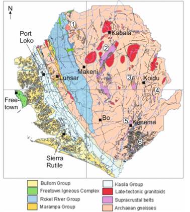
Sierra Leone lies within the West African Craton with the site specifically located within the Freetown Peninsula, which is underlain by the Freetown Complex, see Figure 6. The coastal areas of Sierra Leone are generally low-lying and flat; however, the Freetown Peninsula is defined by an abrupt mountain range that forms the eastern boundary. This mountain range defines the eastern outcrop of the Freetown Complex that is a major funnel-shaped intrusion, with the centre of the intrusion situated offshore in the Atlantic [1]. This is interbedded with seams of clay, clay-sand mixtures and lignite [2].
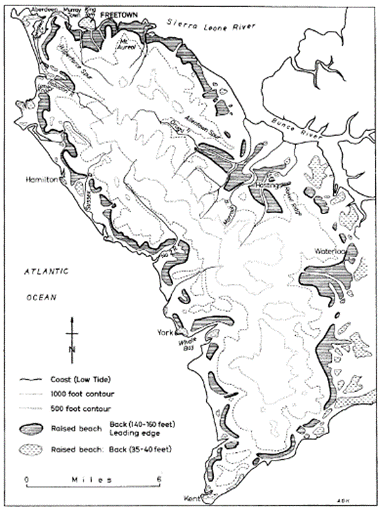
The coastal areas of the peninsula are defined by a series of raised beaches (see Figure 7) that are formed of unconsolidated clayey sand and silts that have previously been classified as part of the Bullom series [3]. The Bullom Group is the youngest stratigraphic group in Sierra Leone and comprises poorly consolidated Cenozoic sediments [2]. There have been very few detailed studies of the Bullom Group undertaken, however it is described as a poorly consolidation coarse quartzofelspathic sand. Moreover, the coastal deposits around the Freetown Peninsula are not contemporaneous with the deeper Bullom series and therefore have been cautiously classified as Bullom Group deposits for the Freetown development. The site-specific deposits are distinctly red in colour and weather / solidify into a laterite rock, which was observed as a common earthwork construction material across the Freetown area.
A site-specific ground investigation was carried out for the project that included an onshore borehole campaign alongside offshore geophysics and sub-bottom profiling. It was originally intended to also conduct offshore boreholes, however the COVID-19 pandemic hit at the time of organising the investigation, and due to a shortage of available skills within the country, it became practically impossible due to the programme delays and associated escalating costs that would have ensued.
The investigation identified that the ground conditions comprise very soft to soft clays, overlying loose to medium dense clayey sands, overlying a stiff clay, which could confidently be classified as the Bullom Group. The onshore boreholes also identified a variable thickness of Made Ground comprising laterite fill and boulders that were assumed to come from a historic revetment shoreline protection, although no records were available and the exact original coastline was difficult to determine from available information. The offshore geophysics results were cross correlated against the boreholes to determine the variability of the strata across the berth site. The sub-bottom profiling indicated a wide range of bed profiles that were noted to be relatively steeply sloping in some places, greater than would be expected of a very soft clay, indicative of the variability of the composition of the superficial strata.
Geotechnical Challenges
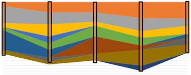
When the piling commenced in June 2022, it became quickly evident that ground conditions were more complex than previously assumed. The piles were penetrating to a depth under self-weight or with less vibrations or driving force than was initially anticipated. Based on this, a series of offshore CPTs were procured using a ground investigation contractor from the neighbouring country, Guinea. Despite the complex properties of the clay presenting challenges for the CPT campaign, the successful CPTs were able to validate the highly variable nature of the ground across the berth, with the layers of clay and sand less defined than previously understood from the onshore boreholes and geophysics, see Figure 8 (showing very soft and soft clays in grey/yellow with variable density sands from very loose to moderately dense indicated by the blue, green and dark orange tones, ultimately underlain by a dense sand in dark yellow and stiff clay at depth). The CPTs also indicated that the softer material extended to greater depths than originally indicated.
Considering the additional information provided by the CPTs, along with the records of the already-installed piles, the design team carried out an optioneering review to assess potential remedial solutions, which included consideration for removing the soft clay material, altering the design of the hinterland, reducing the initial dredge depth, altering the structural design and carrying out additional ground improvement. These options were reviewed against programme and cost implications, with consideration of the mobilised marine spread and high standing time charges. Ultimately the cofferdam design was reassessed and adapted to include lengthening of the anchor and return sheet piles, which were deemed to be the most impacted by the difference in the ground conditions.
A key benefit of using steel piles is that they are flexible and can be adapted to increase lengths and change plan arrangements. Utilising the spare piles and the redundancy in the original design layout, the sheet pile sections could be adapted and cut down into shorter extension sections to increase the lengths of the main anchor wall piles. Another consequence of the challenging ground conditions meant that there was significant creep extension of the sheet pile walls during installation, which benefitted the project as less sheet pile sections were then ultimately required, allowing additional sections to be cut down and reused elsewhere across the structure.
Further to alterations to the project design, a monitoring system was put in place alongside a Monitoring Action Plan. This was developed based on the detailed 2D and 3D soil-structural interaction analyses carried out in Plaxis, see Figure 9. The reclamation sequence was assessed in Plaxis and broken down into several key sub-stages for which predicted displacements were determined. These were used to develop a traffic-light system of allowable deflections for the reclamation works.
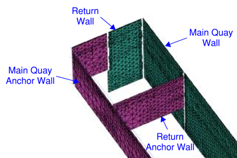
The monitoring system comprised a series of targets installed on all the pile walls and tiltmeters installed on the main quay wall. The prisms were ‘pinged’ by an automatic total station that provided updated movement readings on an hourly basis. The data was automatically uploaded to an online portal, allowing access for the engineers in country and the design team in the UK. Mobilisation and installation of inclinometers was considered but was decided against due to timescales of procuring the equipment and difficulty of installation.
The reclamation works were carried out under a controlled sequence of stages, using an observational method to track displacements against predictions, whilst feeding real-life results back into the Plaxis models. Beckett Rankine provided an on-site geotechnical engineering representative to work collaboratively with the dredging contractor and main Contractor to adapt the sequence against the monitoring results and design calculations. The dredger was a Trailing Suction Hopper Dredger (TSHD) with relatively small hopper capacity up to a maximum of 1,000m3, although most loads were between 700-800m3. Each load was delivered within an approximate 3 to 4 hour window, allowing live multiple monitoring data readings to be reviewed to understand the behaviour of the box ahead of each load, see Figure 10. The monitoring data indicated that the filling had an almost immediate effect on the cofferdam walls, giving an indication of the sand quantities within the shallow soft clay layer increasing the permeability of the ground.
One complexity of filling on top of the soft clay was that the fill weight was essentially causing localised failure and heave of the clay, which therefore caused differential loading of the walls where the clay had accumulated. This effect could not be captured in the design modelling due to relative unpredictability, depending on exact location of the filling, as it was highly localised to placement of the sand. However, the observational approach, with the sophisticated monitoring system, allowed the project team to track this effect and review it against the broad design assumptions and capacities of the cofferdam structure.
The ground improvement works originally entailed vibro compaction of the hydraulic fill to ensure it was uniformly compacted and to reduce further settlements once the berth is operational. However, considering the ground conditions, the ground improvement design was adapted to include stone columns within the underlying soft clay. These were constructed using the same vibration compactor poker, with the stone only placed over the clay column height. Further CPTs were undertaken after the reclamation and ahead of the ground improvement works to allow an accurate profiling of the hydraulic fill and clay layers, so that the work could be optimised for the relevant vibro compaction and stone column vertical extents and transitions. The stone columns were placed on a regular grid across the cofferdam box to enable faster consolidation of the soft clays under the weight of the hydraulic fill, improve the clay properties through consolidation and enable better load distribution to reinforce the clays. The ground improvement will reduce long-term settlements of the berth throughout operation, future maintenance of the berth pavement surface is anticipated to be within standard requirements for a typical bulk terminal berth.
Discussion and Conclusions
Sierra Leone, along with several other countries in Africa, is rich in resources and needs more port facilities to handle the expected increase in cargo volumes in coming years. It has been a stable country to work in with a good labour force and some suitable construction materials available locally. However, as there were no locally based contractors with the skills and equipment required to take on the construction contract, an experienced international marine contractor was appointed following a tender process.
The planning, design and construction of a new cargo berth within an existing port in West Africa has been an interesting project. Timing and circumstances have made it more challenging with key activities compromised by unexpected global events, including the COVID-19 pandemic and international conflicts, which affected transport logistics and costs of imported materials, especially steel.
The NEC4 construction contract has provided the opportunity for collaborative working between Contractor, Client and Project Manager. This can benefit a project throughout, starting with ECI stage for refining designs to suit the Contractor’s most efficient way of working through to change management as and when needed.
Every project has its own challenges to overcome and lessons that can be learnt. In this case, international events have added to the challenges of constructing new marine structures in complex ground conditions at a location far away from back-up support equipment and supplies.
References
[1] Wells, M.K. (1962), Structure and petrology of the Freetown Layered Basic Complex of Sierra Leone.
[2] Macfarlane, A, Crow, M.J., Arthurs, J.W., Wilkinson, A.F. and Aucott, J.W. (1981). The geology and mineral resources of Northern Sierra Leone. Oveseas Memoirs. (Institute of Geological Sciences), No. 7.
[3] Goodenough, K.M., Jones, D and Ford, J. (2018) Geological mapping of Sierra Leone: baseline assessment and next steps.
[4] Gregory, S. (1962). The raised beaches of the peninsula area of Sierra Leone, Transactions and Papers (Institute of British Geographers), No. 31, pp 15-22.