
This year we have been commissioned to carry out a number of UXO risk assessments prior to construction work in the Thames; in cases where works are close to London Underground tunnels the assessments have also included a detailed consequence analysis as is required by LUL. In the past UXO risk assessments in London have tended to be carried out on the simplistic basis that the area was heavily bombed during World War 2 so the risk of encountering a UXO is ‘high’. Using the ‘Clients’ Guide for Assessing Risks on UXO Sites’ published by CIRIA as our starting point we have developed a more scientific approach. Our first step was to collect all the archive data we could locate, and there is a great deal of it, on the density of bomb landings in each area of London as well as data on the sizes of German WW2 bombs and the percentage which failed to detonate.
The great majority of undetonated bombs which landed on land were recorded following impact and subsequently defused; by contrast the bombs which landed in the river and failed to detonate were often not logged. Using this data we developed a probabilistic methodology for calculating the risk presented by unexploded ordnance to any marine piling operation; our method enables a realistic assessment of the risk cross referenced to HSE standards. Appropriate and cost effective solutions can then be adopted for dealing with the identified risk. Having developed this method we have found it equally applicable for other operations which disturb the river bed such as archaeological survey probing and dredging operations.
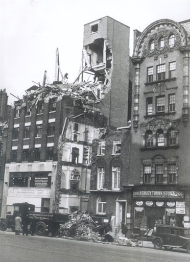
During our data gathering we were interested to find this photograph in Westminster City Archives which shows the site of our offices taken on the morning of 10 November 1941 after a strike by a high explosive bomb. The tall building on the left is Minster house which was subsequently repaired, the pair of houses in the middle of the photo were beyond repair and were demolished. The building we now occupy was built in their place in the 1950s. The building on the right still exists.
